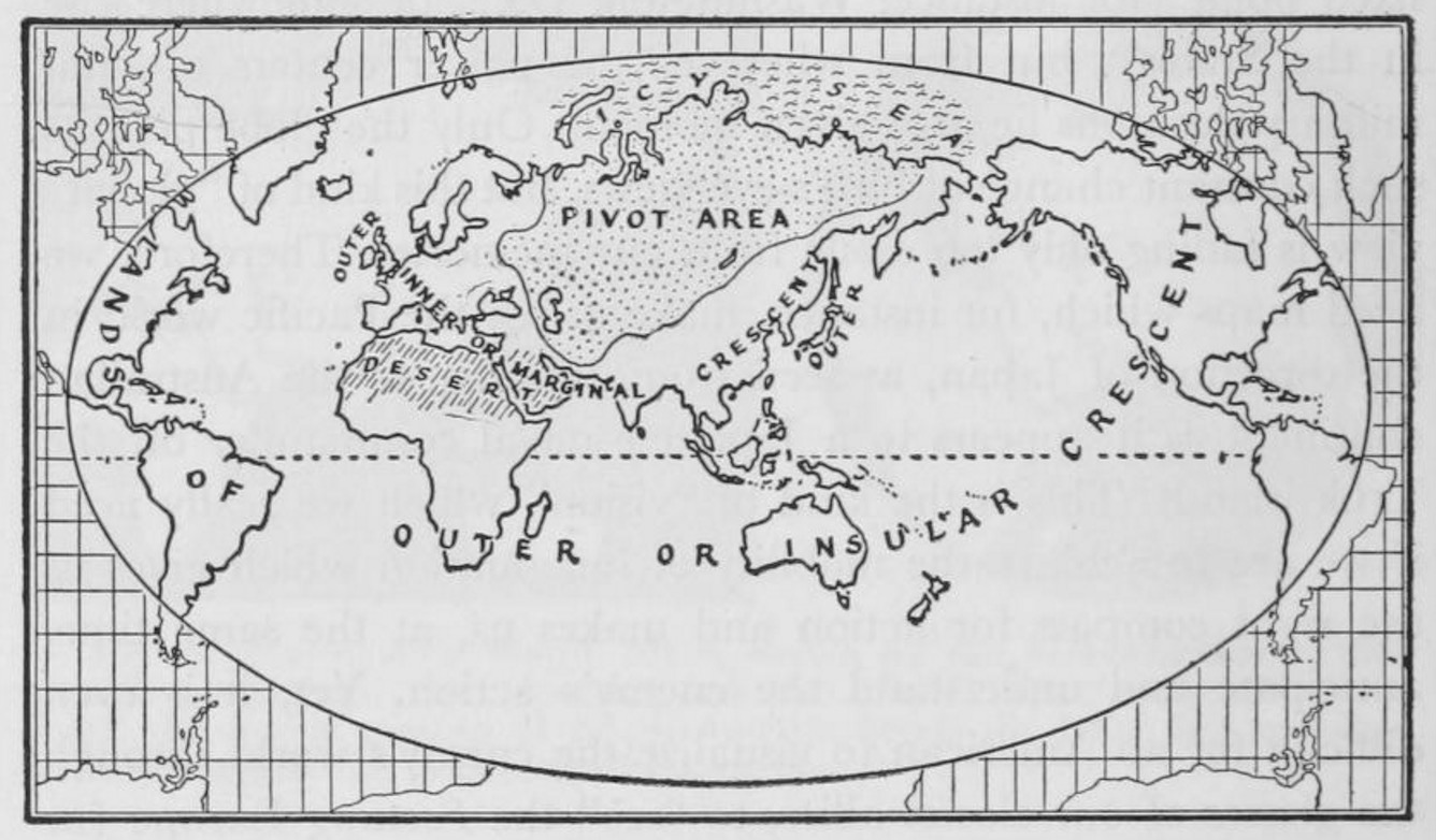
The map of the natural seats of power, with its very peculiar oval shape, is quite well known and has a strong symbolic value. It comes from an article by British geographer Halford J. Mackinder, ‘The Geographical Pivot of History’, which was published in the Geographical Journal in 1904 and has since become one of the great classics of the canon of both Geopolitics and Geostrategy (Mackinder, 1904).

Source: H.J. Mackinder, ‘The Geographical Pivot of History’, The Geographical Journal, avril 1904, p. 435. This map is now in the public domain.
The author of this article is the English geographer Halford J. Mackinder (1861–1947) who had introduced the teaching of Geography at the University of Oxford in 1887, before creating twelve years later the School of Geography in the same institution. He was when it was published also the director of the London School of Economics since December 1903. Mackinder was promoting a certain conception of Geography, understood as a unitary discipline combining both its human and physical dimensions. He was committed to both laying the foundations of the new discipline in Britain and showing its possible application in different domains and particularly its pertinence for political decision makers. It is important to stress how his academic work was going hand in hand with his activity as a militant for constructive imperialism: he was working towards furthering a great ambition, imperial unity for Greater Britain.
The map itself was drawn by Bernhard Vernon Darbishire (1865-1935), a cartographer who is almost forgotten nowadays but was of some renown in his time. Born 1865 in Dwygyfylchi in Wales, he studied at Trinity College, Oxford. He followed Mackinder’s Geography courses which gave rise to a vocation as a professional cartographer. We find at the bottom of the map both the mention ‘Darbishire & Stanford’ and ‘Oxford Geographical Institute’. It refers to the limited company he set up in partnership with Stanford of London and which had opened a shop selling maps in Oxford with an adjoining cartography workshop. In 1904, Darbishire was on the teaching staff of the School of Geography at Oxford, where he was responsible for teaching the techniques cartography.
This map comes from an article entitled ‘The Geographical Pivot of History’, published by Halford Mackinder in April 1904. It is based on a paper which was given before a learned society, the prestigious Royal Geographical Society in London, on 25 January 1904, two weeks day for day before the outbreak of the Russo-Japanese war. Mackinder’s approach in this article was incredibly ambitious, as his objective was no less than to find ‘seek a formula which shall express certain aspects, at any rate, of geographical causation in universal history’. (Mackinder 1904, 422)
Mackinder who was taking as a starting point the opposition between sea-power and land-power in History was explicitly mentioning the works of American Navy Captain Alfred Thayer Mahan. There he was formulating a very bold working hypothesis according to which the vast region of continental and arctic drainage in Central Asia had been for a very long time, the ‘geographical pivot of history’, the central region from which had originated the great invasions which had marked the history of the Old Continent. In his mind, this zone, which he also described as the ‘Heart-land’– in two words with a hyphen–was meant to remain the ‘pivot region of the world’s politics’.
In an extremely iconoclastic way, Mackinder was denouncing the Eurocentric readings of the world, very common at the time : he claimed that the history of Europe was subordinated to that of Asia. No matter how ambitious was his approach, Mackinder was, however, not marked by hubris: he was at the same time being modest most appropriately stressing that this was simply a first approximation. Whilst this text if often wrongly presented as an expression of determinist reasoning, it must be stressed that it was rather informed by a form of possibilism, for he thought that ‘Man and not Nature initiates, but Nature in large measure controls. My concern is with the general physical control, rather than the causes of universal history.'(Mackinder 1904, 422)
This small-scale map in black and white occupies an entire page of the article. It presents an oval shape, which is characteristic of the work of Bernard Darbyshire who is the author of a whole series of maps based on this type of pseudo-cylindrical projections. It has been drawn using a Mercator projection, but the peripheral parts of the map, which would have made the polar regions appear extremely large, have simply been eliminated.
Richard E. Harrison and Hans Weigert, ‘World View and Strategy », in Hans W. Weigert and Vilhjalmur Stefanson, Compass of the World, New York, Macmillan, 1944, p. 78.
Since Mackinder was thinking the world from the point of view of sea power, using a Mercator projection seemed quite pertinent. Whilst it is at the time the most common projection used to draw world maps, the choice a projection is never neutral: it contributes here to make the pivot zone look more massive and therefore more menacing on the map.
Mackinder represents the world by showing three elements which have a particular importance and are described in the legend of the map which is found underneath it. They are the ‘Pivot area – wholly continental’, the ‘Outer crescent – wholly oceanic’, and the ‘Inner crescent – partly oceanic and partly continental’.
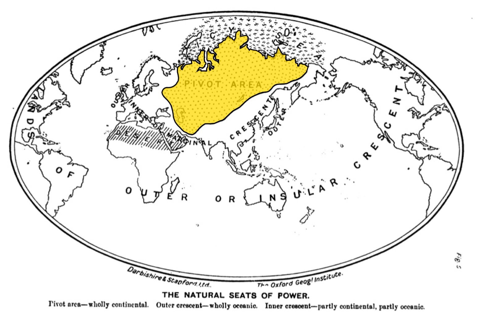
As we have seen, the hypothesis Mackinder is putting forward in his article, the validity of which he is testing, is that there exists in the pivot region a space of cardinal importance for the world, the pivot-zone, represented on the map by a spotted pattern. The space in question is simply constructed by taking the space of continental and arctic drainage, which is clearly visible on the hydro-graphic map of Asia. It includes not only the central part of the Russian empire, but also the whole of the Persian Empire, apart from the coastal regions. Using the Mercator projection results in making the pivot zone appear comparatively much bigger than it really is. This can be interpreted as part of the visual construction of the menace which it represented for the British empire.
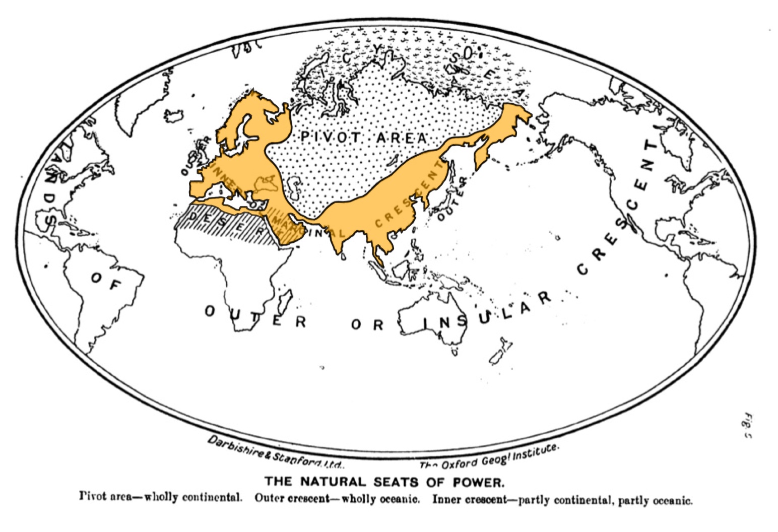
The inner or marginal crescent, highlighted in orange above, the peripheral regions of both Europe and Asia. Mackinder describes in his article how it comprises the great civilizations of History. This is a space on which at the time of writing the pressure from Russia was felt, in particular as part of the questions of the Nearer East, Middle East and the Far East. Mackinder was not specifically analyzing the situation of Europe.
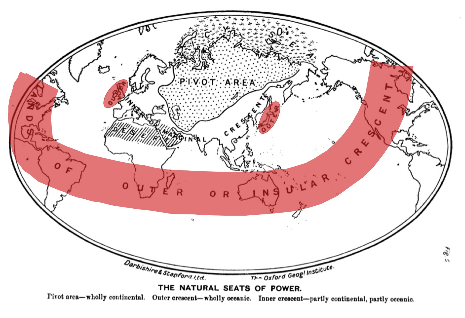
The outer or insular crescent, highlighted in red above, includes not only the United States and the British dominions (Canada, Newfoundland, South Africa, Australia and New Zealand), but also the two allies Great Britain and Japan. This is the oceanic domain, the realm of Sea Power. Need is to stress how the British Isles are on this map detached from Europe, just like Japan is from Asia. This reflects in the strategic context of the time a fundamental reality. The fact that the United States is represented twice, both to the West and to the East, translates visually the fact that American power must be reckoned with both in the Atlantic Ocean and the Pacific Ocean where it was present both in Hawaii and the Philippines.
It is generally possible to draw interesting indications form where the centre of the map is. The difficulty here comes from an original feature of the map, which is that America is represented twice, both to the left and to the right of the map. It is therefore necessary to focus primarily on where the centre of both crescents, inner and outer, is. India is indeed at the centre of both crescent which reflects that we are dealing with an India-centric reading of the world.
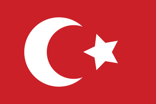
The Ottoman flag. Par Kerem Ozcan (en.wikipedia.org) [Public domain], via Wikimedia Commons
Mackinder seems to have found part of his inspiration in the shape of the Ottoman flag. This is what reveals a sentence in an article he published the following year in which he described, ‘Canada, Australasia, and South Africa as set like the crescent on the Turkish flag, with India in the place of the star.’ (Mackinder 1905, 140) A star was also used as a symbol for India at the time and the Star of India was displayed for instance in the fly of the blue ensign of the Royal Indian Navy, which also had the Union flag in the corner.
The main purpose of this article was to stress the threat represented by the centrifuge pressure exerted by Russia’s continental power on both Britain and her Japanese ally. The catastrophic scenario envisaged by Mackinder was, however, the possible combination between the pivot state, the Russian Empire, and the German Empire who occupied at the time the central strategical position in Europe.
The fact that Mackinder was thinking in terms of a challenge-response pattern must be emphasized. In his mind, the challenge from land-power could have a beneficial effect for it would not leave the British sea-power any option but to rise to it. For this academic who was actively campaigning for constructive imperialism, the way forward was that of imperial unity for Greater Britain which would provide the necessary man-power to be able to project power in the peripheral regions of both Asia and Europe, would the urgent need arise.
References
Mackinder, H. J. (1904). The Geographical Pivot of History. The Geographical Journal, 23(4), 421–437.
Mackinder, H. J. (1905). Man-Power as a Measure of National and Imperial Strength. National and English Review, 45, 136–143.
Mackinder, H. J. (1919). Democratic Ideals and Reality: A Study in the Politics of Reconstruction. Constable.

Ping : La carte des centres naturels de la puissance de Mackinder (1904) – L'espace stratégique